About Mount Rwenzori National Park
Get comprehensive information regarding the Rwenzori Mountains national park . Mount Rwenzori National Park Uganda is a designated UNESCO World Heritage Site located within the Rwenzori Mountain range. Mount Rwenzori national park encompasses an area of around 1,000 km2 (386 square miles) and features the third highest mountain peak in Africa, as well as numerous lakes, waterfalls, and glaciers. The park is renowned for its exquisite botanical specimens.
Based on the existing data, the Rwenzori Park covers around 100,000 hectares in western Uganda. It includes the main part of the Rwenzori Mountains range, which is home to Africa’s third highest peak, Mount Margherita, standing at 5,109 meters. The presence of glaciers, lakes, and waterfalls in the Rwenzori area makes it one of the most visually appealing alpine environments in Africa. The Rwenzori region contains a variety of natural ecosystems that support a diverse range of uncommon species and unique plants, including the impressive heather plant.
Features of Rwenzori Mountain
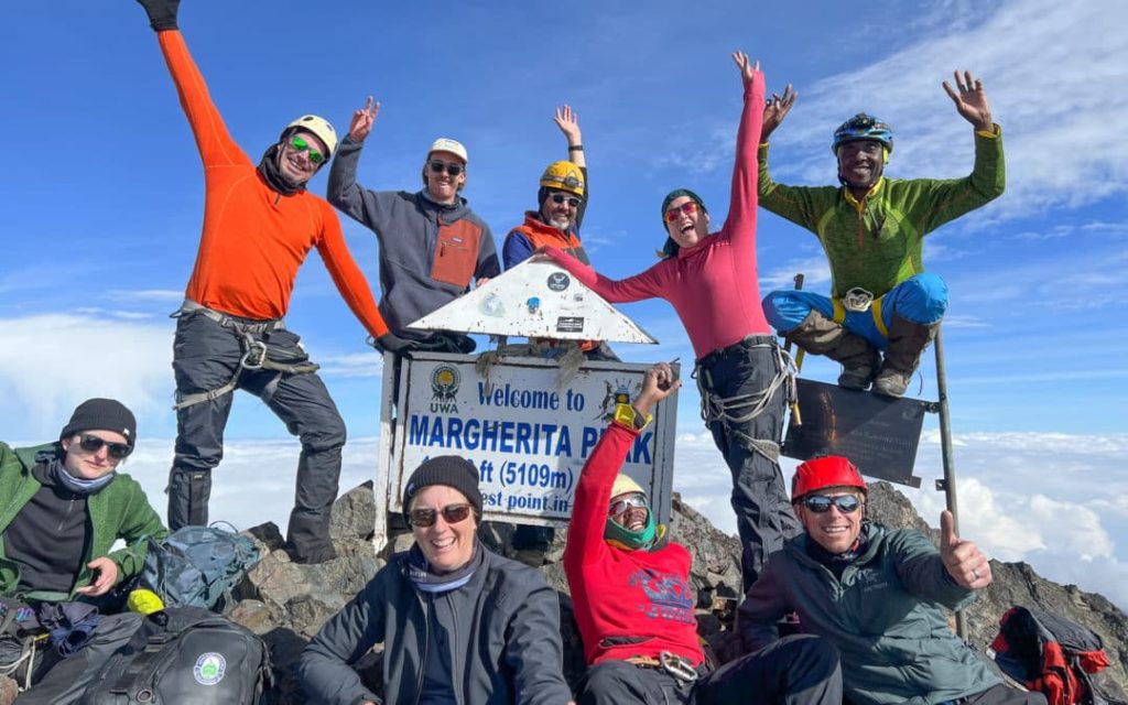
The Margherita peak, with an elevation of 5,109 meters, holds the distinction of being the tallest peak among all the Rwenzori mountain ranges. Consequently, it ranks as the third highest peak in Africa. This location is situated at the summit of Mount Stanley, which is one of the mountain ranges located within the Rwenzori Mountain range in Uganda. This summit surpasses the cloud cover and maintains a perpetual covering of snow. Those who have the audacity to transform their dreams into reality gather here. Mount Speke, with an elevation of 4,890 meters, and Mount Baker, with an elevation of 4,844 meters, are the fourth and fifth highest summits respectively. These peaks are separated by a deep green valley. The valley is abundantly populated with a wide variety of vibrant plant and animal species of varying sizes. The Rwenzori mountain ranges surpass the Swiss Alps in terms of elevation, and are home to glaciers that serve as one of the origins of the River Nile, the longest river on the planet. The local inhabitants referred to these mountain ranges as the ‘mountains of the moon’. The word was initially employed by Ptolemy, the geographer from Alexandria, on the global map. The mountains were believed to be the origin of the River Nile since the melting snow from these ranges supplies water to some of the most distant tributaries of the Nile.
The ranges span over 80 miles and encompass one of the most striking arrays of ecosystems worldwide. Furthermore, these locations are situated within a short distance of one another and experience consistent warmth from the tropical rainforests, as well as frigid temperatures from the glacier ice. The European explorer Henry M. Stanley promptly dubbed these ranges Rwenzori, from a local term that signifies a person who brings rain. Indeed, this mountain has the ability to generate rainfall. The mountain receives rainfall for approximately 250 days per year, which nourishes the rich vegetation in the park. You can reach this altitude location in Uganda in under five hours by traversing grassland and montane forest vegetation zones. You will encounter wild banana trees and lianas during your journey.
Vegetation of Rwenzori Mountain
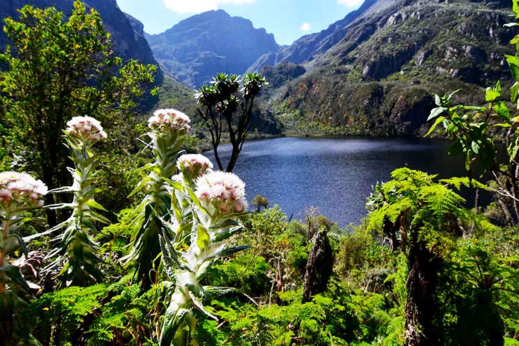
Rwenzori Mountain National Park, located at an elevation of 5,109m above sea level, offers a remarkable and fulfilling experience by showcasing nature in its pristine and stunning form. The distinctive and aesthetically pleasing mountain flora undergoes variations as one ascends through different altitude zones. The vegetation varies from a wide array of tropical rainforests to bamboo forests and alpine cloud forests. At the highest point, there is alpine vegetation that supports unique plant species that are unable to survive in any of the lower vegetation zones. The picturesque panorama evokes a sense of awe, instilling within you a profound sensation of triumph. Once more, situated above the rainforest, lies a bamboo grove that extends to an altitude above 9,500 feet. Bamboo is a species of grass that may reach a height of more than three feet and grow over a hundred feet in just two months. The forest kind is likewise an extraordinary habitat to traverse. Located above the bamboo, there exists a heath zone that spans around 12,000 feet. This area is characterized by the presence of lichen-covered heather trees. The towering trees overshadow the ground, concealing the mosses and liverwort. The trees have a height of 40 feet and are very short shrubs that thrive in the Scottish moorlands.
As previously remarked, the higher one ascends, the lower the situation becomes. Upon reaching the Alpine zone, situated at an altitude beyond 12,000 feet, one will encounter a terrain characterized by lower areas that are inhabited by towering entities. The flora in this area is exclusively found in the Afro-Alpine zone and consists of extraordinary specimens such as towering trees, groundsel, and lobelia. The highest point of the area stretches beyond 14,500 feet and is characterized by rocky landscape adorned with black lichens and brown mosses.
At an elevation of 16,763 feet (5,109m), the Margherita peak stands as the highest point among several mountain ranges, which reach a maximum altitude of 14,500 feet. Located at the summit of Mount Stanley, the Rwenzori mountains are adorned with snow and battered by stormy glaciers. In 1906, Luigi di Savoia, the duke of Abruzzi, successfully completed the initial climb to the highest summit with the assistance of J. Petigax, J. Brocherel, and C. Ollier. The Rwenzori mountain ranges, with an elevation of 5,109m, rank as the third tallest mountains in Africa, surpassed only by Kilimanjaro and Mount Kenya. The Rwenzori Mountain National Park encompasses a significantly larger alpine region compared to the others, spanning an area of 99,600 hectares, with 70% of it situated at elevations exceeding 2,500 meters.